


1682
Europa
17 Bll. Teilkarten von Südwestdeutschland, Elsaß, Lothringen, Flandern u. a., 1680
Engraving
Estimation:
€ 300 / $ 321 Résultat:
€ 312 / $ 333 ( frais d'adjudication compris)
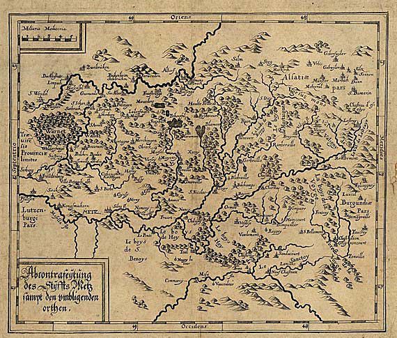
Westeuropa. - Südwestdeutschland 17 ll. maps of south-west Germany, Alsace-Lorraine et al u. a. Engravings, Germany and Netherlands 17th-18th century. From 28,5 : 32 cm to 83 : 57 cm.
Collection of maps of wesern Germany, north-east France, Belgium et al. - Among them: Abcontrafeyhung des Stiffts Metz . Around 1620. - Comitatus Wertheimici. After B. Cantzler, 1626 (re-engraving from the 1617 edition). Oehme p. 67. - Lotharingia ducatus. By W. Blaeu, Amsterdam around 1640. Koeman 4250.2. - Germaniae superioris et inferioris. By J. Hoffmann, Nuremberg around 1680. - Alsatiae landgraviatus. By J. von Sandrart, Nuremberg around 1690. - Pars occidentalis palatinatus et electoratus Rheni ducatus. By J. G. Walther, Frankfurt around 1690. - Totius fluminis Rheni novissima descriptio . 2 maps on 1 l. by N. Visscher, Amsterdam around 1690. - 11 more maps of Flanders, Cologne, Meissen, Vogtland, Rhenish-Palatinate, Baden, Switzerland and Greece. - Some mounted and browned, margins with obvious blemishes and defective spots in places.
Collection of maps of wesern Germany, north-east France, Belgium et al. - Among them: Abcontrafeyhung des Stiffts Metz . Around 1620. - Comitatus Wertheimici. After B. Cantzler, 1626 (re-engraving from the 1617 edition). Oehme p. 67. - Lotharingia ducatus. By W. Blaeu, Amsterdam around 1640. Koeman 4250.2. - Germaniae superioris et inferioris. By J. Hoffmann, Nuremberg around 1680. - Alsatiae landgraviatus. By J. von Sandrart, Nuremberg around 1690. - Pars occidentalis palatinatus et electoratus Rheni ducatus. By J. G. Walther, Frankfurt around 1690. - Totius fluminis Rheni novissima descriptio . 2 maps on 1 l. by N. Visscher, Amsterdam around 1690. - 11 more maps of Flanders, Cologne, Meissen, Vogtland, Rhenish-Palatinate, Baden, Switzerland and Greece. - Some mounted and browned, margins with obvious blemishes and defective spots in places.
1682
Europa
17 Bll. Teilkarten von Südwestdeutschland, Elsaß, Lothringen, Flandern u. a., 1680
Engraving
Estimation:
€ 300 / $ 321 Résultat:
€ 312 / $ 333 ( frais d'adjudication compris)